
| ||||||
Downscaling October-December Seasonal Climate Forecasts over Sri Lanka – Some Preliminary Results
It is known that the large-scale atmospheric circulation across the Indian Ocean sector has a strong degree of predictability in the October-December season. Global climate model forecasts are archived at IRI from 1950 to present and are available to quantify this large-scale predictability. This provides a basis for investigating predictability at small spatial scale across Sri Lanka. We ask the question: for a given large-scale wind forecast across the region, what are the details of the rainfall pattern to expect across Sri Lanka? 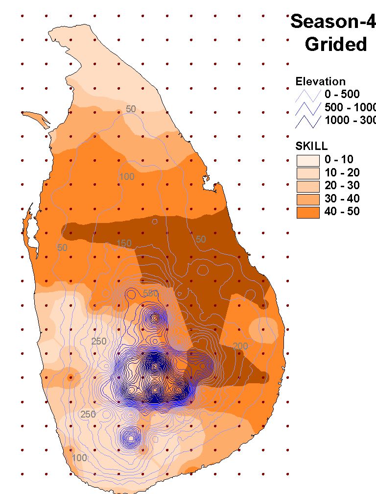
Two ways to answer this question are
The second approach has the problem that the details of the relationships are vulnerable to sampling error, and we may introduce details into the forecasts that have no physical basis. However, they can be used to give a first indication of predictability, especially when they are interpreted using knowledge of the physical climate system. The preliminary results here have been created using the following system. The Global Climate Model results are the average of 24 forecasts made for each season 1950-1980 using the ECHAM4.5 model. These forecasts assume perfect knowledge of the Sea-surface temperature – for real-time forecasts there is a need to first forecast the sea-surface temperature – these skill evaluations can therefore be considered approximately representative of the skill achievable with short-lead time forecast (i.e. forecast made as the October-December season starts), since the relevant large-scale patterns of sea-surface temperature anomalies usually change only very slowly from September to December. The analysis proceeded:
Some of the additional work that is needed includes:
With regard to item (i) above, there is good indication that the increased skill found on the eastern side of Sri Lanka is physically based – since wetter years appear to be associated with SST forcing that enhances the easterly surface wind component across the region – which will hit the eastern side of the island first and give rise to particularly enhanced precipitation on eastward facing slopes, while the western side of the island, especially in the lee of mountains, may be less affected. This could be investigated using a high resolution regional climate model. Project Coordinator
|